
June 23, 2011
CONTAMINATED FISHERIES
PROHIBITION ORDER NO. GSN-2011-042
WHEREAS the Regional Director General of the Department
of Fisheries and Oceans for the Gulf Region has reason to believe
that fish of the species set out in section 2 of the annexed
order, in the area described in the Schedule to that order, are
contaminated;
THEREFORE, the Regional Director General for the
Department of Fisheries and Oceans for the Gulf Region pursuant
to subsection 3(1) of the Management of Contaminated Fisheries
Regulations, made by Order in Council P.C. 1990-1121 of June
14, 1990*, hereby revokes Contaminated Fisheries Prohibition Order
No. GSN-2011-039 issued on June 16, 2011 and issues the annexed
Order prohibiting fishing for contaminated fish.
Issued at Moncton, New Brunswick, on June 22, 2011.
__________________
F.R. Breau
Acting Regional Director General
Gulf Region
* SOR/90-351, 1990 Canada Gazette Part II, p. 2489 CONTAMINATED FISHERIES
PROHIBITION ORDER NO. GSN-2011-042
ORDER PROHIBITING FISHING FOR CONTAMINATED FISH
Short Title
1. This order may be cited as the Contaminated Fisheries
Prohibition Order No. GSN-2011-042.
Prohibition
2. Subject to subsection 3(2) of the Management of Contaminated
Fisheries Regulations, no person shall, in the area described in
the schedule, fish for any species of clams, mussels, oysters and
any other bivalve molluscs, including bay scallops.
Coming into Force
3. This Order shall come into force on the date of signature
and remains in force unless otherwise revoked. CONTAMINATED FISHERIES
PROHIBITION ORDER NO. GSN-2011-042
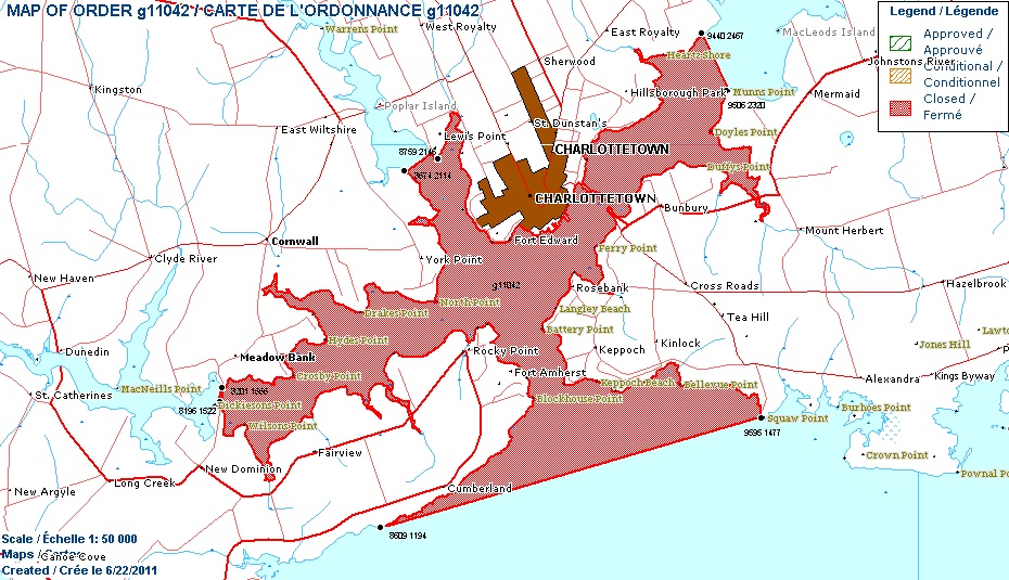
SCHEDULE
AREA
The following areas within or adjacent to Queens County, Prince
Edward Island:
Charlottetown Harbour and surrounding waters inside a
line drawn from grid reference 495957E 5114774N to grid
reference 486097E 5111948N then from grid reference
481960E 5115224N to grid reference 482011E 5115566N then
from grid reference 486741E 5121142N to grid reference
487596E 5121466N then from grid reference 494402E
5124676N to grid reference 495063E 5123208N. (Refer to
map Charlottetown 11 L/3).
Note: When the boundary of an area is expressed in grid
references, those grid references are based on the Universal
Transverse Mercator Grid system set out on the National
Topographic Series Map, Scale 1:50,000 published by the
Department of Energy, Mines and Resources (North American Datum
1983). NOTICE
The Regional Director General for the Gulf Region, Department of
Fisheries and Oceans, hereby gives notice that the area listed
below in the province of Prince Edward Island is closed for
fishing for any species of clams, mussels, oysters and any other
bivalve molluscs, including bay scallops:
Charlottetown Harbour and surrounding waters inside a
line drawn from grid reference 495957E 5114774N to grid
reference 486097E 5111948N then from grid reference
481960E 5115224N to grid reference 482011E 5115566N then
from grid reference 486741E 5121142N to grid reference
487596E 5121466N then from grid reference 494402E
5124676N to grid reference 495063E 5123208N. (Refer to
map Charlottetown 11 L/3).
Note: When the boundary of an area is expressed in grid
references, those grid references are based on the Universal
Transverse Mercator Grid System set out in the National
Topographic Series Map, Scale 1:50,000 published by the
Department of Energy, Mines and Resources (North American Datum
1983).
Refer to Contaminated Fisheries Prohibition Order No. GSN-2011-
042 issued on June 22, 2011, or contact your local Fishery
Officer for further information or visit the Web site of the
Department of Fisheries and Oceans, Gulf Region, under Orders
Registry, at the following address: http://www2.glf.dfompo.gc.ca/fam-gpa/cp/ord/index-e.php.
Contaminated Fisheries Prohibition Order No. GSN-2011-042 comes
into force on June 22, 2011.
Contaminated Fisheries Prohibition Order No. GSN-2011-039 issued
on June 16, 2011, is revoked.
F.R. Breau
Acting Regional Director General
Gulf Region
Telephone: (902) 566-4050
Fax: 902-368-3748
Follow us
Instagram:
@peifishassoc
Facebook:
@princeedwardislandfishassoc