
September 21, 2010
Attached is a copy of the satellite direction of 4 tags that has been released from tuna that was tagged in association with the Experimental Catch and Release tuna tagging project. There are currently 4 tags floating in the waters around PEI. They will be hard to find, but if people could keep an eye out in these locations it would be good.
Two tags out of 59 have released from fish that have died after release.
This is a very low mortality rate and it looks good for the study overall.
3 of the 59 tags have detached because they were not securely attached or for some malfunction.
The coordinates are:
46 38 32 N 59 56 33 W
45 49 24 N 61 43 32 W
46 48 08 N 60 54 10 W
46 14 17 N 61 20 50 W
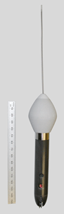
There is a $500 reward for each. Below is a picture of a tag so fishers will not know what they look like:
If you find one of these tags, please contact Pat O'Neill at poneill@eastlink.ca for details on what to do with it next!
Telephone: (902) 566-4050
Fax: 902-368-3748
Follow us
Instagram:
@peifishassoc
Facebook:
@princeedwardislandfishassoc